
Sale!

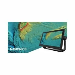
Lowrance C-Map® Reveal: Darwin To Esperance Chart
Original price was: $329.99.$98.99Current price is: $98.99.
- Safe and Secure Payments, Always
- Shop with Peace of Mind
- Guaranteed High Quality
- Online assistance, always just a message away.

Product Info
C-MAP® Reveal charts save time and help you find your key fishing spot faster. They give you a high-def look at the structures and contour changes on the seafloor. Just turn on the Shaded Relief setting in your chartplotter, and you’ll see the best fishing or diving spots with ease.
Selected areas have a high-def C-Map Reveal layer which shows you more accurate depth variations. It even includes detailed marina and port plans. Everything you need to fish anywhere from Darwin to Esperance.
Features
- Detailed charts from Darwin to Esperance
- High-def C-Map® Reveal layer on specific areas
- Saves time searching
- Detailed display of wrecks, ledges, reefs and bottom structures
- Includes full C-Map® Max-N+ vector navigation data
- New features include Custom Depth Shading, High Resolution Bathy, Genesis layer and satellite imagery
- Convenient – just turn on Shaded Relief in chartplotter to use
- Includes detailed marina and port plans
Be the first to review “Lowrance C-Map® Reveal: Darwin To Esperance Chart”
Related products
Sale!
Marine Audio
Original price was: $394.00.$99.99Current price is: $99.99.
Sale!
Marine Electronics
Original price was: $89.99.$62.99Current price is: $62.99.
Sale!
Marine Electronics
Original price was: $42.99.$30.09Current price is: $30.09.
Sale!

Marine Electronics
Original price was: $362.00.$98.99Current price is: $98.99.
Sale!
Marine Charts
Original price was: $199.99.$97.99Current price is: $97.99.
Sale!
Marine Audio
Original price was: $379.99.$95.99Current price is: $95.99.
Sale!

Marine Electronics
Original price was: $59.99.$41.99Current price is: $41.99.
Sale!
Marine Audio
Original price was: $343.00.$99.99Current price is: $99.99.
Reviews
There are no reviews yet.